Map Of North Africa Southwest Asia
Muz Play
Mar 21, 2025 · 7 min read
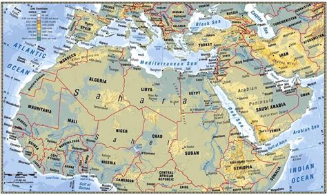
Table of Contents
A Comprehensive Look at the Map of North Africa and Southwest Asia: Unveiling a Region's Rich Tapestry
The region encompassing North Africa and Southwest Asia, often referred to as the Middle East and North Africa (MENA) region, presents a captivating blend of history, culture, and geography. Understanding its complex map is crucial to grasping its diverse landscapes, political dynamics, and the interwoven narratives of its inhabitants. This article delves deep into the cartography of this significant area, exploring its physical features, geopolitical boundaries, and the human imprint that has shaped its evolution over millennia.
The Physical Geography: Mountains, Deserts, and Waterways
The map of North Africa and Southwest Asia is dominated by vast deserts, towering mountain ranges, and fertile river valleys—a dramatic interplay of contrasting landscapes.
The Sahara Desert: A Sea of Sand
The Sahara Desert, one of the largest hot deserts globally, stretches across a significant portion of North Africa. Its expanse is marked by shifting sand dunes, rocky plateaus (hamadas), and occasional oases providing pockets of life amidst aridity. The Sahara's influence on the region's climate, human settlement patterns, and historical migrations is profound. Its seemingly inhospitable nature has shaped cultural adaptations and continues to present significant challenges for resource management and development. Understanding its vastness and its impact is key to interpreting the map of this region.
The Atlas Mountains: A Spine of North Africa
The Atlas Mountains form a formidable mountain range running through Morocco, Algeria, and Tunisia. These mountains significantly impact weather patterns, creating a climatic diversity within a relatively small geographical area. Their peaks provide refuge for unique flora and fauna, and their valleys have historically supported agricultural settlements. The Atlas Mountains are not just a geographical feature; they are a cultural and historical landmark, influencing trade routes, population distribution, and the development of distinct regional identities.
The Fertile Crescent: Cradle of Civilization
The Fertile Crescent, a historically significant region encompassing parts of modern-day Iraq, Syria, Lebanon, Israel, Palestine, and Jordan, is a crescent-shaped area of relatively fertile land. This area, watered by the Tigris and Euphrates rivers, is widely considered the cradle of civilization. The map clearly highlights the vital role of these rivers, which supported early agriculture, the rise of cities, and the development of some of the world's oldest known civilizations. Its strategic importance, both historically and presently, cannot be overstated.
The Arabian Peninsula: Deserts and Coastal Plains
The Arabian Peninsula, the largest peninsula in the world, is dominated by the vast Arabian Desert. However, its coastal plains offer contrasting landscapes, with fertile regions supporting agriculture and settlements. The peninsula’s geography, particularly its coastal areas and access to the Red Sea and the Arabian Gulf, has shaped its historical role as a major trading hub and a center for cultural exchange. The map reveals the strategic importance of its location, at the crossroads of Africa, Asia, and Europe.
Political Boundaries and Geopolitical Dynamics
The map of North Africa and Southwest Asia is a patchwork of sovereign nations, each with its unique history, political system, and cultural identity. However, these boundaries are often fluid and contested, reflecting a complex geopolitical landscape.
Post-Colonial Borders: Legacy of Imperialism
Many of the current political boundaries are a legacy of colonial rule, drawn often without regard for existing ethnic or tribal affiliations. This arbitrary division has led to ongoing conflicts and tensions in many parts of the region. Examining the map in this context reveals the lingering effects of colonialism and its impact on contemporary political stability. Understanding the historical context behind these borders is crucial for interpreting current events and challenges.
Conflicts and Tensions: A Contested Landscape
The region has witnessed numerous conflicts, often fueled by competing claims over territory, resources, and religious or ideological differences. These conflicts have significantly impacted the lives of millions and continue to shape the region's political landscape. The map can highlight areas prone to conflict, indicating regions where resources are scarce, borders are disputed, or ethnic tensions are high.
The Rise of Nationalism and Regionalism: Shifting Identities
Nationalism and regionalism are powerful forces shaping the political dynamics of the region. The map reflects this complexity, with diverse national identities existing alongside overlapping regional affinities and historical ties. Understanding the interplay of these factors is crucial for grasping the political realities of the region.
The Role of Water Resources: A Source of Conflict and Cooperation
Access to water resources, particularly in arid and semi-arid areas, is a significant factor influencing regional stability. The map reveals the strategic importance of rivers like the Nile, Tigris, and Euphrates, as well as shared aquifers. Competition over these resources has historically and continues to fuel conflict, while cooperative management efforts are essential for regional stability.
Cultural and Historical Significance: A Tapestry of Civilizations
The map of North Africa and Southwest Asia is not merely a geographical representation; it’s a visual record of thousands of years of human history and cultural interaction.
The Cradle of Civilization: Ancient Empires and Innovations
The Fertile Crescent’s fertile lands nurtured some of the earliest civilizations, including the Sumerians, Babylonians, Assyrians, and Egyptians. The map reflects the locations of ancient cities and empires, revealing the development of agriculture, writing, law, and other significant societal advancements. These early civilizations left an indelible mark on the world, and their legacy continues to resonate today.
The Spread of Religions: A Shared Heritage
The region is the birthplace of several major religions, including Judaism, Christianity, and Islam. The map illustrates the geographical spread of these religions, highlighting sites of religious significance and the influence of religious beliefs on the region’s cultural landscape. The intermingling of these faiths has shaped the region's identity in profound ways, both unifying and diversifying its cultural tapestry.
Trade Routes and Cultural Exchange: A Crossroads of Civilizations
The region has historically served as a crucial crossroads for trade routes, connecting Asia, Africa, and Europe. The map reflects the paths of ancient trade routes, illustrating the flow of goods, ideas, and cultural influences across continents. This exchange played a vital role in shaping the region's diverse cultural landscape and contributed to its economic development.
Colonial Influence and Modern Transformations: A Legacy of Change
Colonial rule has left a significant impact on the region’s political and socio-economic structures. The map reflects the legacy of European colonization, illustrating the boundaries imposed by imperial powers and the resulting impact on national identities and political systems. The post-colonial era has witnessed significant social, economic, and political transformations, further shaping the region's complex identity.
Exploring the Map: Tools and Resources
To fully appreciate the complexities of the North Africa and Southwest Asia region, utilizing various map resources is essential.
Physical Maps: Understanding Topography and Climate
Physical maps showing elevation, terrain, and climate zones are invaluable for grasping the region's diverse geography. These maps help visualize the challenges posed by deserts, mountains, and water scarcity, impacting settlement patterns, agriculture, and transportation networks.
Political Maps: Visualizing National Boundaries and Geopolitical Dynamics
Political maps showcasing national borders, capitals, and major cities help understand the current political landscape. These maps help to analyze geopolitical dynamics, identifying potential areas of conflict or cooperation based on border disputes, resource allocation, or ethnic tensions.
Historical Maps: Tracing the Evolution of Boundaries and Empires
Historical maps illustrating the shifting boundaries of empires and civilizations throughout history provide crucial context for understanding the region's present-day dynamics. These maps offer a deeper insight into the historical reasons behind current political divisions, conflicts, and cultural interactions.
Thematic Maps: Highlighting Specific Aspects of the Region
Thematic maps focused on specific features like population density, religious distribution, or economic activity can provide in-depth insights into various facets of the region. These maps allow for a nuanced understanding of how different factors interact to shape the region's complex human geography.
Conclusion: A Region of Contrasts and Interconnections
The map of North Africa and Southwest Asia is a dynamic and intricate representation of a region rich in history, culture, and geographical diversity. Understanding its physical features, political boundaries, and historical evolution is crucial for comprehending its complexities and the challenges it faces. By utilizing various map resources and considering the interwoven narratives of its people, we can gain a deeper appreciation for this pivotal region's crucial role in global history and its continued influence on the world stage. The map is not just a static image; it's a dynamic representation of a region constantly evolving and adapting, shaped by the intricate interplay of geography, history, and human endeavor.
Latest Posts
Latest Posts
-
What Happens During The Reduction Stage Of The Calvin Cycle
Mar 27, 2025
-
Is Solid To Liquid Endothermic Or Exothermic
Mar 27, 2025
-
What Does A Negative Enthalpy Mean
Mar 27, 2025
-
Divides The Body Into Anterior And Posterior Portions
Mar 27, 2025
-
Claim Of Fact Value And Policy
Mar 27, 2025
Related Post
Thank you for visiting our website which covers about Map Of North Africa Southwest Asia . We hope the information provided has been useful to you. Feel free to contact us if you have any questions or need further assistance. See you next time and don't miss to bookmark.
