What Type Of Distortion Does The Good Homolosine Preserve
Muz Play
Mar 26, 2025 · 6 min read
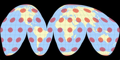
Table of Contents
What Type of Distortion Does the Goode Homolosine Projection Preserve?
The Goode Homolosine projection, a popular equal-area map projection, is renowned for its unique approach to minimizing distortion. Unlike projections that prioritize preserving shape (conformal projections) or distance (equidistant projections), the Goode Homolosine focuses on maintaining area accuracy. However, this choice comes at the cost of significant distortions in shape and distance, particularly at the higher latitudes. Understanding the specific types of distortion this projection preserves and sacrifices is crucial for its effective and responsible use.
Understanding Map Projections and Distortion
Before diving into the specifics of the Goode Homolosine, let's establish a foundational understanding of map projections and the inherent distortions they introduce. The Earth, being a three-dimensional sphere (or more accurately, an oblate spheroid), cannot be perfectly represented on a two-dimensional plane without some degree of distortion. This distortion manifests in several ways:
- Shape Distortion (Angular Distortion): The shapes of landmasses and other features are altered. This is often referred to as conformality – a conformal projection preserves angles locally.
- Area Distortion (Scale Distortion): The relative sizes of landmasses are altered. An equal-area projection preserves the relative areas of features, ensuring that Greenland doesn't appear larger than South America, as it does on some other projections.
- Distance Distortion: The distances between points are altered. An equidistant projection preserves distances accurately along certain lines.
No single projection can perfectly preserve all three aspects simultaneously. The choice of projection depends on the specific application and the type of distortion that is considered most acceptable.
The Goode Homolosine: An Equal-Area Compromise
The Goode Homolosine projection, developed by J. Paul Goode in the early 20th century, is an interrupted pseudo-cylindrical projection. The term "interrupted" signifies its unique construction. Instead of projecting the entire globe onto a single continuous surface, it divides the globe into multiple sections or "interrupting" the projection in specific regions, reducing the distortion in high-latitude areas by creating gaps. These interruptions are strategically placed to minimize the distortion of continental shapes.
What it Preserves: Area
The Goode Homolosine's primary strength lies in its preservation of area. It's an equal-area projection, meaning the relative sizes of landmasses are accurately represented. This makes it particularly suitable for thematic mapping that requires accurate portrayal of geographical phenomena involving area, such as population density, resource distribution, or land use. The ratio of areas on the map accurately reflects the ratio of areas on the Earth's surface. This is the key feature that sets it apart and makes it a preferred choice for certain cartographic applications.
What it Distorts: Shape and Distance
While the Goode Homolosine excels at preserving area, it introduces significant distortions in shape and distance. The interruptions, while minimizing area distortion, inherently create discontinuities and distortions in the shapes of landmasses, particularly along the interruption lines. These distortions are more pronounced in higher latitudes. The distances between points are also significantly distorted, especially between interrupted regions. Accurate distance measurements are generally not possible using this projection.
Understanding the Interruptions
The interruptions in the Goode Homolosine are not arbitrary. Goode cleverly designed the projection to minimize distortion in the most densely populated and geographically significant regions of the world. The projection effectively balances the preservation of area with the reduction of distortion in crucial continental areas, leading to a more useful representation compared to uninterrupted equal-area projections which are severely distorted at higher latitudes.
Comparing the Goode Homolosine to Other Projections
To fully appreciate the Goode Homolosine's unique characteristics, it's beneficial to compare it to other popular projections:
-
Mercator Projection: A conformal projection preserving shape, the Mercator drastically distorts area at higher latitudes (making Greenland appear far larger than it actually is). It's useful for navigation but unsuitable for representing relative sizes of landmasses.
-
Gall-Peters Projection: Another equal-area projection, the Gall-Peters aims to rectify the area distortions of the Mercator. However, it significantly distorts shapes, particularly towards the poles. While it is accurate with area, its shape distortion is considered visually unappealing by some.
-
Robinson Projection: A compromise projection attempting to balance area, shape, and distance distortions. It doesn't perfectly preserve any of these but offers a more aesthetically pleasing representation than many equal-area projections. However, it is not an equal area projection.
The Goode Homolosine stands out because it balances its commitment to area accuracy with a minimization of shape distortion in important land masses through the introduction of interruptions. While it doesn't offer the aesthetic appeal of the Robinson projection or the navigational accuracy of the Mercator, its relative accuracy in portraying areas is paramount for specific cartographic tasks.
Applications of the Goode Homolosine Projection
The Goode Homolosine projection finds its most suitable applications where the accurate representation of area is paramount. Some examples include:
-
Thematic Mapping: Showing population distribution, resource allocation, or agricultural production. Equal-area representation allows for a clear and accurate comparison of areas based on the specific data.
-
Choropleth Maps: Maps that use shading or color to represent data values across geographic areas. The Goode Homolosine ensures accurate representation of the underlying area data.
-
Global Datasets Representation: Providing a visually appealing yet reasonably accurate representation of global data. While shape distortions exist, the minimized impact on major landmasses makes it more useful than a severely distorted uninterrupted equal-area projection.
-
Educational Purposes: Illustrating the concepts of map projections and distortions, highlighting the trade-offs involved in creating world maps.
Limitations and Considerations
Despite its advantages, the Goode Homolosine is not without limitations:
-
Interruptions: The interruptions create discontinuities in the map, making it less suitable for applications requiring continuous representation of features or seamless transitions across regions.
-
Shape Distortion: Significant shape distortion in some areas, particularly along the interruptions and in higher latitudes, should be taken into account when interpreting the map.
-
Distance Distortion: Accurate distance measurement is impractical, due to the non-preservation of distances.
-
Visual Appeal: Some find the interrupted nature visually less appealing compared to continuous projections.
Conclusion: A Powerful Tool for Specific Applications
The Goode Homolosine projection is not a universal solution for all mapping needs. Its strength lies in its ability to minimize area distortion while reasonably preserving shape in significant land masses. Understanding its strengths – primarily its preservation of area – and its limitations – significant shape and distance distortions – is crucial for making informed decisions about its application. By carefully considering the nature of the data being presented and the specific cartographic requirements, cartographers can utilize the Goode Homolosine's unique properties to create accurate and insightful visualizations of global phenomena. Its focus on preserving the relative sizes of countries and continents makes it an invaluable tool for thematic mapping and the depiction of spatially distributed data, despite its unavoidable distortions in other aspects of the Earth's geometry. The key is understanding that this projection's value lies in its prioritization of equal-area representation, making it a powerful tool, but one that must be used judiciously and with careful consideration of its inherent limitations.
Latest Posts
Latest Posts
-
Is Osmosis High To Low Or Low To High
Mar 26, 2025
-
What Is The Electron Configuration For Cobalt
Mar 26, 2025
-
How Do You Calculate The Average Acceleration
Mar 26, 2025
-
What Subatomic Particles Make Up An Atom
Mar 26, 2025
-
What Is A Role Conflict In Sociology
Mar 26, 2025
Related Post
Thank you for visiting our website which covers about What Type Of Distortion Does The Good Homolosine Preserve . We hope the information provided has been useful to you. Feel free to contact us if you have any questions or need further assistance. See you next time and don't miss to bookmark.
