How Do You Calculate Stream Gradient
Muz Play
Apr 01, 2025 · 6 min read
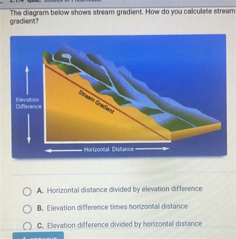
Table of Contents
How to Calculate Stream Gradient: A Comprehensive Guide
Stream gradient, a fundamental concept in hydrology and geomorphology, represents the slope of a stream channel. Understanding how to calculate it is crucial for various applications, from predicting erosion and sediment transport to assessing the suitability of a river for specific activities like kayaking or fishing. This comprehensive guide will walk you through different methods of calculating stream gradient, from simple calculations using elevation differences to more advanced techniques incorporating geographic information systems (GIS). We'll cover the importance of accurate data acquisition and explore the nuances of interpreting the results.
Understanding Stream Gradient
Stream gradient, often expressed as a percentage or in feet/miles (or meters/kilometers), describes the vertical drop of a stream channel over a given horizontal distance. A steeper gradient indicates a faster-flowing stream with higher erosional power, while a gentler gradient suggests a slower-flowing stream with less erosional capacity. The gradient is not uniform along a stream's course; it varies depending on the underlying geology, topography, and other factors.
Why is Calculating Stream Gradient Important?
Calculating stream gradient is vital for numerous reasons:
-
Erosion and Sediment Transport: Gradient directly influences a stream's erosional and depositional processes. Steeper gradients promote erosion, while gentler gradients favor deposition. Understanding the gradient helps predict sediment transport rates and potential impacts on downstream areas.
-
Habitat Assessment: Stream gradient significantly influences the type of aquatic habitats present. Different organisms thrive in streams with varying gradients. Knowing the gradient helps in ecological assessments and conservation efforts.
-
Water Resource Management: Gradient plays a crucial role in determining water flow velocity and discharge. This information is essential for water resource management, including dam design, irrigation planning, and flood control.
-
Geomorphic Analysis: Gradient is a key parameter in geomorphic studies, helping to understand the evolution of river systems and landforms. Changes in gradient over time can reflect tectonic activity or human impacts.
-
Engineering Projects: Accurate gradient calculations are vital for engineering projects near or involving streams, such as bridge construction, pipeline routing, and flood mitigation strategies.
Methods for Calculating Stream Gradient
Several methods exist for calculating stream gradient, each with its own advantages and disadvantages:
1. Simple Rise-Over-Run Method
This is the most straightforward method, suitable for relatively short stream reaches where elevation changes are easily measured.
Steps:
-
Determine the vertical drop (rise): Measure the difference in elevation between two points along the stream channel. This can be done using a topographic map, altimeter, or GPS device.
-
Determine the horizontal distance (run): Measure the horizontal distance between the two points along the stream channel. This is usually measured along the stream's thalweg (the line of lowest elevation in the channel). Again, topographic maps, GPS, or measuring tools can be used.
-
Calculate the gradient: Divide the rise by the run and multiply by 100 to express the gradient as a percentage:
Gradient (%) = (Rise / Run) * 100
Example:
If the elevation difference between two points is 10 meters (rise) and the horizontal distance is 100 meters (run), the gradient is:
Gradient (%) = (10 m / 100 m) * 100 = 10%
Limitations: This method is only accurate for short stream reaches where the curvature of the Earth is negligible. For longer reaches, more sophisticated methods are necessary.
2. Using Topographic Maps
Topographic maps provide detailed elevation information, allowing for the calculation of gradient over longer stream reaches.
Steps:
-
Identify stream channel: Locate the stream channel on the topographic map.
-
Select points: Choose two points along the stream channel. The further apart the points, the better the representation of the average gradient.
-
Determine elevations: Note the elevations of the selected points from the contour lines on the map.
-
Measure horizontal distance: Use the map's scale to measure the horizontal distance between the points along the stream thalweg.
-
Calculate the gradient: Use the rise-over-run formula as described above.
3. Using Geographic Information Systems (GIS)**
GIS software provides powerful tools for analyzing spatial data, including stream networks and elevation models. GIS offers the most accurate and efficient way to calculate stream gradient over extensive reaches.
Steps:
-
Obtain elevation data: Acquire a digital elevation model (DEM) covering the study area. Numerous sources, such as government agencies and online repositories, provide freely available DEMs.
-
Import stream data: Import a stream network shapefile or feature class into the GIS software.
-
Create stream profiles: Use GIS tools to generate stream profiles, which show the elevation changes along the stream channel. This is often done using the "profile" tool found in most GIS software packages.
-
Calculate gradient: The GIS software can directly calculate gradient from the stream profile data. This often involves calculating the slope of the line connecting adjacent points along the stream profile using various functions like calculating the difference in elevation between each consecutive point and dividing it by the distance between the points. Many GIS software applications offer tools that perform this calculation automatically.
Advantages of using GIS: GIS allows for the calculation of gradient over large areas, provides high accuracy, and facilitates visualization and analysis of the results.
4. Using GPS and Surveying Equipment**
Modern GPS devices and surveying equipment provide highly accurate elevation and distance measurements.
Steps:
-
Establish base points: Create base points along your desired stream segment to which you will record your readings.
-
Record data: Use a GPS or total station to measure the elevation and coordinates of points along the stream channel. The accuracy of this method is heavily reliant on the quality of the equipment used.
-
Calculate gradient: Use the rise-over-run formula with these recorded values.
Interpreting Stream Gradient Results
The interpretation of stream gradient results depends on the context of the study. Consider the following:
-
Comparison to regional averages: Compare the calculated gradient to average gradients of similar streams in the region. This helps assess whether the gradient is unusually steep or gentle.
-
Spatial variation: Analyze how the gradient changes along the stream's length. Identify areas with particularly steep or gentle gradients. This can provide insights into geomorphic processes.
-
Relationship to other variables: Investigate the relationship between stream gradient and other factors, such as discharge, sediment load, and channel morphology. This often involves statistical analysis using tools such as regression analysis, allowing for identifying and interpreting correlation between these variables.
-
Units of Measurement: Be consistent with units when calculating and reporting the gradient. Clearly state the units used (e.g., %, meters/kilometer, feet/mile).
Potential Errors and Sources of Uncertainty
Several factors can introduce errors in stream gradient calculations:
-
Inaccurate elevation data: Errors in elevation measurements from maps or GPS devices can significantly affect gradient calculations.
-
Channel sinuosity: The winding nature of stream channels makes accurate horizontal distance measurement challenging.
-
Data resolution: The resolution of the elevation data (e.g., DEM resolution) influences the accuracy of gradient calculations. Higher resolution data generally yields more accurate results.
-
Errors in stream network delineation: Errors in identifying the stream's thalweg during field data collection.
Conclusion
Calculating stream gradient is a crucial task in various hydrological and geomorphological studies. The choice of method depends on the available resources, the scale of the study area, and the desired accuracy. While the simple rise-over-run method is suitable for short reaches, GIS offers a powerful tool for analyzing gradient over larger areas with high accuracy. Accurate data acquisition and careful interpretation of results are essential for obtaining meaningful insights into stream dynamics and the various processes influenced by stream gradient. Remember always to clearly specify the units used and document the methods applied. This ensures reproducibility and comparability with other studies. Careful consideration of potential errors and uncertainties can significantly improve the accuracy of your calculations and the reliability of your conclusions.
Latest Posts
Latest Posts
-
Draw A Structural Formula For 3 Bromo 4 Chloro 1 1 Dimethylcyclohexane
Apr 02, 2025
-
What Is A Primary Standard Chemistry
Apr 02, 2025
-
How Do You Convert From Atoms To Grams
Apr 02, 2025
-
How Do Positive Ions And Negative Ions Form
Apr 02, 2025
-
Density Of Water At Different Temperatures Chart
Apr 02, 2025
Related Post
Thank you for visiting our website which covers about How Do You Calculate Stream Gradient . We hope the information provided has been useful to you. Feel free to contact us if you have any questions or need further assistance. See you next time and don't miss to bookmark.
